Convective Outlook for Oct 11, 2026
Issued as Day 1 Convective Outlook at · Valid:
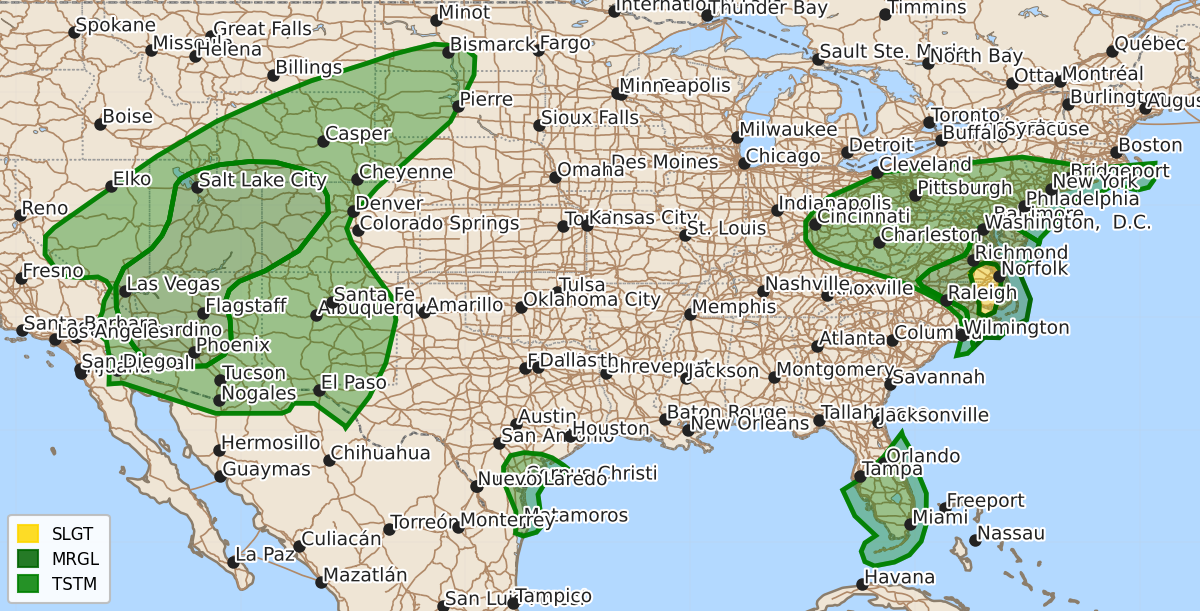
Summary
A few tornadoes may occur across parts of eastern North Carolina and southeastern Virginia into the early evening, while isolated severe gusts are possible across the Desert Southwest and Four Corners region.
Product Text
000 ACUS01 KWNS 112001 SWODY1 SPC AC 112000 Day 1 Convective Outlook NWS Storm Prediction Center Norman OK 0300 PM CDT Sun Oct 11 2026 Valid 112000Z - 121200Z ...THERE IS A SLIGHT RISK OF SEVERE THUNDERSTORMS ACROSS PARTS OF EASTERN NORTH CAROLINA AND SOUTHEASTERN VIRGINIA... ...SUMMARY... A couple of tornadoes remain possible across parts eastern North Carolina and southeastern Virginia into early evening. Additional storms with isolated severe gusts will be possible in parts of the Desert Southwest and Four Corners region. ...20Z Update... Severe probabilities were trimmed behind the primary north/south-oriented broken band of thunderstorms spreading eastward across eastern NC and southeastern VA. While thunderstorms have been weakening while approaching the coast, a moist air mass and clockwise-curved low-level hodograph (around 250-300 m2/s2 0-1 km SRH per VWP data) will still conditionally support a couple of tornadoes within Tornado Watch #681 into early evening. Elsewhere, the previous forecast remains on track and no changes were made. ..Weinman.. 10/11/2026 .PREV DISCUSSION... /ISSUED 1129 AM CDT Sun Oct 11 2026/ ...NC/VA vicinity... Midday water-vapor imagery shows a dry slot/vorticity lobe wrapping through the base of the larger-scale remnants/cyclone associated with Isaias and progressing eastward across the southern Appalachians/Carolinas. Surface analysis places a triple point over northwest NC with a maritime warm frontal zone draped east-northeast into the DelMarVa. Despite considerable cloud cover according to visible-satellite imagery, surface temperatures are gradually warming into the mid to upper 70s across eastern NC and far southeast VA. This modest heating has led to the development of around 1000 J/kg MLCAPE across eastern NC and weaker buoyancy farther north near Richmond, VA (a few hundred J/kg). The forced band of broken thunderstorm activity moving east across NC will likely be the primary feature for severe weather across this general region through the late afternoon. A few supercells embedded within the north-south oriented band will potentially pose a risk for a few additional tornadoes and perhaps an isolated risk for strong to locally severe gusts (see MCD 2361 for short-term details). Have added a level-1 intensity highlight for the area of greatest tornadic supercell potential through mid afternoon. By late this afternoon, it is possible (albeit uncertain) that a narrow corridor adequately destabilizes ahead of triple point as it develops northeastward into central VA. If sufficient destabilization occurs and sustained/robust storms also develop, a localized tornado/wind threat could ensue prior to sunset. ...Desert Southwest/Eastern Great Basin... Remnants of tropical cyclone Rachel are currently centered in the CA/NV/AZ border vicinity, at the base of a broad upper trough covering much of the western CONUS. These remnants are forecast to progress northeastward today, moving quickly through the Great Basin and ending the period over central/eastern MT. Persistent large-scale forcing for ascent and the aforementioned moisture will support scattered thunderstorms. Strong low to mid-level southwesterly flow will result in occasionally intense bowing segments capable of strong gusts, particularly in any areas that can experience filtered daytime heating. $$