Convective Outlook for Oct 22, 2026
Issued as Day 1 Convective Outlook at · Valid:
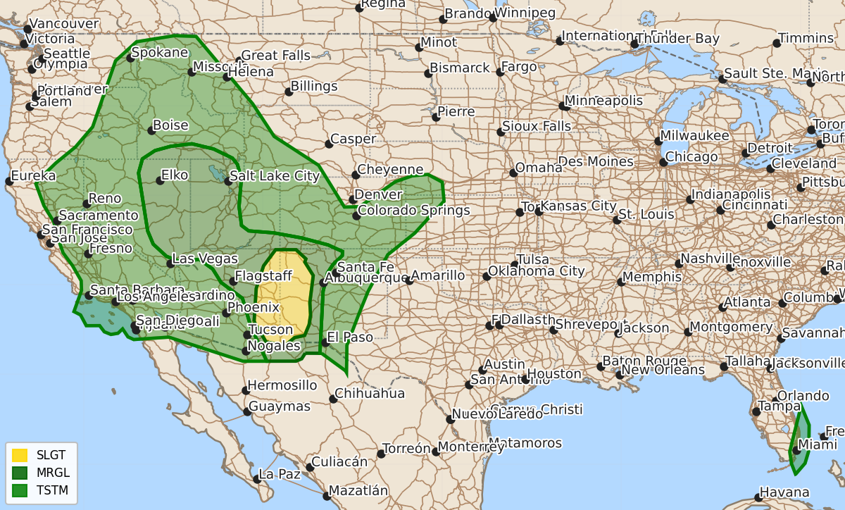
Summary
Scattered severe thunderstorms are expected across the Southwest and Great Basin tonight, with the most intense storms occurring in western New Mexico. These storms may produce large hail, damaging winds, and potentially a tornado or two.
Product Text
000 ACUS01 KWNS 230102 SWODY1 SPC AC 230101 Day 1 Convective Outlook NWS Storm Prediction Center Norman OK 0801 PM CDT Thu Oct 22 2026 Valid 230100Z - 231200Z ...THERE IS A SLIGHT RISK OF SEVERE THUNDERSTORMS FROM EASTERN ARIZONA INTO WESTERN NEW MEXICO... ...SUMMARY... Scattered severe thunderstorms remain possible across the Southwest and Great Basin tonight. The most intense cells are expected across parts western New Mexico through the remainder of this evening. Large hail, damaging winds, and a tornado or two are all possible. ...Southwest and Great Basin... Evening water-vapor imagery showed the upper low over central CA has transitioned into a broad, negatively titled open wave. Mid-level southerly flow remains quite strong on the eastern periphery of the trough over eastern AZ, NM, and farther north into the Great Basin. The main associated vort max should continue northeastward from NV into UT and WY/ID tonight. Farther south, mid-level subsidence and dry air behind a surface trough were observed moving across southern CA/NV into western and central AZ. This should serve as the effective western terminus to deep convection. To the east of the wind shift, ongoing convection has remained relatively strong and well organized owing to moderate buoyancy and strong/deep, but modestly veering wind profiles. A mix of supercells and linear clusters should continue into this evening as main band of convection gradually shifts into western NM and southern CO. Buoyancy is forecast to gradually decrease through this evening, but with MLCAPE around 1000 J/kg, convection should remain fairly robust well into the evening hours. Favorable deep-layer shear for supercells (EBWD 50-60 kt) will continue to support a risk for hail along with severe gusts. A tornado or two also remains possible, particularly from northwestern NM, northward toward southern CO where low-level flow is backed and terrain influence is supporting larger low-level hodograph curvature. To the north, numerous thunderstorms remain ongoing, but with somewhat weaker presentation. Buoyancy (MLCAPE generally less than 500 J/kg) remains fairly limited, but sufficient for intermittent stronger updrafts, especially as the cold core aloft moves overhead eastern NV and western UT into tonight. With deep-layer shear forecast to remain quite strong overnight, isolated strong to severe storms remain possible. Damaging gusts are the most likely hazard, though sporadic hail will also be possible, particularly with any rotating storms able to be maintained. ..Lyons.. 10/23/2026 $$