Convective Outlook for Oct 23, 2026
Issued as Day 1 Convective Outlook at · Valid:
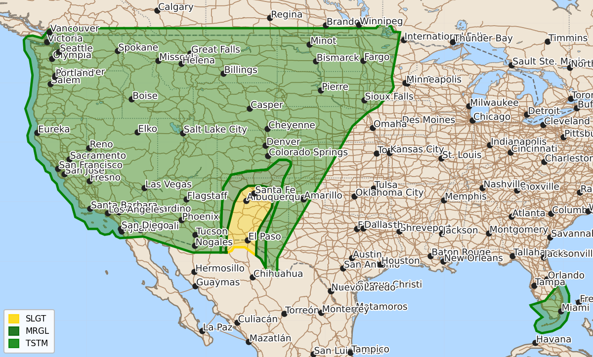
Summary
Severe thunderstorms capable of producing large hail, damaging winds, and an isolated tornado are possible across central New Mexico, southern Colorado, and far west Texas this afternoon through tonight.
Product Text
000 ACUS01 KWNS 231958 SWODY1 SPC AC 231956 Day 1 Convective Outlook NWS Storm Prediction Center Norman OK 0256 PM CDT Fri Oct 23 2026 Valid 232000Z - 241200Z ...THERE IS A SLIGHT RISK OF SEVERE THUNDERSTORMS THIS AFTERNOON/EVENING FOR CENTRAL NEW MEXICO AND FAR WEST TEXAS... ...SUMMARY... Severe thunderstorms with large hail, damaging gusts, and an isolated tornado are possible across portions of New Mexico, southern Colorado, and far west Texas today into tonight. ...20z Update... Latest HRRR/RRFS TLE guidance suggests that a locally more favorable corridor for left-split supercells may manifest across portions of central/east-central NM to the north of ongoing convective development along the Sacramento Mountains. Given the risk for large to very large hail likely to accompany persistent, left-split supercells, the existing CIG1 group for hail was expanded eastward across portions of central/eastern New Mexico to capture this corridor. No other changes were made to the existing outlook with this update as the forecast remains generally on track. See the previous discussion below for additional details. ..Chalmers.. 10/23/2026 .PREV DISCUSSION... /ISSUED 1130 AM CDT Fri Oct 23 2026/ ...NM and far west TX this afternoon into early tonight... An initial shortwave trough will continue to eject north-northeastward over WY as an upstream wave evolves into a new closed low over the lower CO River Valley. A surface cyclone will develop from eastern MT into MB in advance of the lead shortwave trough, with a trailing baroclinic zone across CO/northwest NM and central AZ. A moisture plume persists along and southeast of the baroclinic zone, with the most favorable moisture profiles for thunderstorm development expected this afternoon/evening across NM. Forcing for ascent will be relatively weak across NM this afternoon, so surface heating and terrain influences will drive widely scattered thunderstorm development by early-mid afternoon as temperatures warm into the 60s and 70s (depending on elevation). Observed boundary-layer dewpoints in the low-mid 50s and the warming temperatures will contribute to MLCAPE in the 1000-1500 J/kg with minimal convective inhibition. Long, straight hodographs will persist beneath a belt of enhanced mid-upper flow and will favor supercells this afternoon in NM, with some potential for growth into small clusters/line segments. Large hail and occasional severe outflow gusts are expected to be the primary threats, though an isolated tornado may also occur. The severe threat will peak late afternoon and diminish by early tonight. $$